


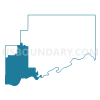
Voting District 310, McIntosh County, Oklahoma
About
Outline

Summary
| Unique Area Identifier | 654415 |
| Name | Voting District 310 |
| County | McIntosh County |
| State | Oklahoma |
| Area (square miles) | 128.30 |
| Land Area (square miles) | 124.49 |
| Water Area (square miles) | 3.81 |
| % of Land Area | 97.03 |
| % of Water Area | 2.97 |
| Latitude of the Internal Point | 35.25233760 |
| Longtitude of the Internal Point | -95.88890040 |
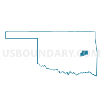
Maps

Graphs
Select a template below for downloading or customizing gragh for Voting District 310, McIntosh County, Oklahoma


Neighbors
Neighoring Voting District (by Name) Neighboring Voting District on the Map
- Voting District 22, Hughes County, OK
- Voting District 23, Okmulgee County, OK
- Voting District 307, McIntosh County, OK
- Voting District 311, McIntosh County, OK
- Voting District 312, McIntosh County, OK
- Voting District 313, Okfuskee County, OK
- Voting District 313, McIntosh County, OK
- Voting District 37, Pittsburg County, OK
- Voting District 48, Pittsburg County, OK
Top 10 Neighboring County Subdivision (by Population) Neighboring County Subdivision on the Map
- Henryetta CCD, Okmulgee County, OK (11,055)
- Eufaula CCD, McIntosh County, OK (5,541)
- North Central Pittsburg CCD, Pittsburg County, OK (4,725)
- Wetumka CCD, Hughes County, OK (2,788)
- Northwest Pittsburg CCD, Pittsburg County, OK (2,378)
- Weleetka CCD, Okfuskee County, OK (2,320)
- Hanna CCD, McIntosh County, OK (961)
Top 10 Neighboring Place (by Population) Neighboring Place on the Map
Top 10 Neighboring Elementary School District (by Population) Neighboring Elementary School District on the Map
Top 10 Neighboring Unified School District (by Population) Neighboring Unified School District on the Map
- Eufaula Public Schools, OK (7,564)
- Canadian Public Schools, OK (4,256)
- Indianola Public Schools, OK (1,773)
- Dustin Public Schools, OK (713)
- Graham Public Schools, OK (638)
- Hanna Public Schools, OK (524)
Top 10 Neighboring State Legislative District Lower Chamber (by Population) Neighboring State Legislative District Lower Chamber on the Map
- State House District 18, OK (35,558)
- State House District 24, OK (35,109)
- State House District 16, OK (33,634)
Top 10 Neighboring State Legislative District Upper Chamber (by Population) Neighboring State Legislative District Upper Chamber on the Map
- State Senate District 8, OK (75,663)
- State Senate District 7, OK (73,650)
- State Senate District 13, OK (73,191)
Top 10 Neighboring 111th Congressional District (by Population) Neighboring 111th Congressional District on the Map
Top 10 Neighboring Census Tract (by Population) Neighboring Census Tract on the Map
- Census Tract 4858, Pittsburg County, OK (4,725)
- Census Tract 8, Okmulgee County, OK (3,352)
- Census Tract 7799, McIntosh County, OK (2,932)
- Census Tract 4846, Hughes County, OK (2,788)
- Census Tract 7801, McIntosh County, OK (2,394)
- Census Tract 4859, Pittsburg County, OK (2,378)
- Census Tract 810, Okfuskee County, OK (2,320)
Top 10 Neighboring 5-Digit ZIP Code Tabulation Area (by Population) Neighboring 5-Digit ZIP Code Tabulation Area on the Map
- 74501, OK (29,073)
- 74437, OK (10,448)
- 74432, OK (9,730)
- 74880, OK (2,239)
- 74442, OK (920)
- 74839, OK (770)
- 74845, OK (494)